Organizational Participation
The Role of Analytics as a Solution to Urban Heat Islands

According to our working definition of sustainability, a practice, process, or entity must have actions, initiatives, or impacts that meet social, environmental, and economic needs without compromising the ability of future generations to achieve their own goals. As for urban heat islands, there are a variety of solutions that exist, but only those which fit within the definition described above will be applicable as long-term sustainability solutions. I have discussed on this site the importance of individual and community collective actions to ignite change, however, those are limited without the help of analytics supporting a sustainable plan for community mitigation campaigns against climate-related issues. Analytics is responsible for informing decisions that will likely fit within the context of sustainability, therefore for this section, we will take a closer look at CAPA Strategies, LLC, an organization that provides data and decisions that support tools for our communities worldwide.
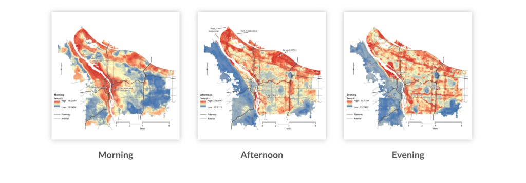
CAPA Strategies, also known as Climate Adaptation Planning Analytics, is an organization that is aiming to build grassroots movements by providing accessible data and analytic tools that allow communities to develop strategies for environmental issues that are equitable. According to their main website, their approach focuses on “social, infrastructural, and ecological aspects of any location for an equitable and holistic approach to community adaption.”1 One of their main flagship services, Heat Watch, is highly important to the issue of urban heat islands because it provides a high-resolution scientific mapping of more than 40 communities across the United States that showcase urban heat islands, the heat distribution through different points of the day, and detailed analysis of the intensity of temperatures and humidity in each city.
In addition to this readily accessible information, the service also serves as a program that allows individuals to be guided through 3 steps to complete a heat watch campaign. Access to more information about how to complete a campaign can be found here.
CAPA Strategies for the past 5 years has been funded by NOAA and recently came into partnership with the National Integrated Heat Health Information System to create an additional mapping campaign that brings more groups and organizations that are interested in participating.2 Their work is essential to a variety of stakeholders as they consider how to mitigate urban heat islands in the future. For example, urban planners who are looking to redesign the landscape to reduce heat in the metropolitan area need visual descriptions of heat distribution and intensity of exposure in order to address the necessary areas that are being impacted the most. This will ensure that those who are impacted at higher rates are addressed in an equitable manner. In the field of public health, heat-related mortality is a consequence of urban heat islands that must be addressed, therefore access to these heat maps also shows areas that may be more vulnerable so those individuals may be targeted.3
As with any solution, there are limitations and barriers that exist. The program designed by CAPA Strategies depends on the applications of those who are interested in the problem. As presented on this site, a problem must be clearly defined before it may be accepted, and therefore unless an individual can see the issue as important, they may not contribute to the community action that the organization is pushing for. In addition, climate-related maps have shown for years the change in temperatures, the loss of the ozone, and much more. Despite the physical evidence that can be seen visually, skeptics and dismissives are likely to argue the validity of such maps which can be seen as both a barrier and limitation. In order to combat these problems, it is important that those who are interested in joining the movement take the time to showcase how the problem directly affects the community in which they are involved. The maps are available for dozens of cities, and if you are able to showcase the temperature changes and explain how the changes have impacted you on a personal level then acceptance is more likely. In addition, presenting information on how the mapping process works when discussing with the average individual is also helpful. CAPA Strategies has provided a recent publication that can be accessed that provides more information on the process of mapping and the tools that are used.
There are many different solutions available to mitigate urban heat islands. Organizations, such as CAPA Strategies, aim to work and reflect the values of communities and provide practical solutions that are effective and sustainable. It may not be the full answer to the problem, but it is a positive step in creating a successful path that will protect those who continue and will continue to suffer from the urban heat island effect.
Endnotes
1. About Us. CAPA. (n.d.). Retrieved March 30, 2022, from https://www.capastrategies.com/about-us
2. NIHHIS-CAPA Urban Heat Island Mapping Campaign Application. NIHHIS. (2022). Retrieved March 30, 2022, from https://nihhis.cpo.noaa.gov/Urban-Heat-Islands/Mapping-Campaigns
3. CAPA Heat Watch: Heating Climate Zone Map. CAPA. (n.d.). Retrieved March 30, 2022, from https://www.capastrategies.com/capa-heat-watch